


Borrowdale
YHA Borrowdale
Hostel · Borrowdale — Riverside setting, shared and private rooms, a self-catering kitchen and facilities for walking and cycling breaks.
Peaks & fells / Scafell Pike
LAKE DISTRICT FELL GUIDE
England’s highest mountain is a substantial fell day, with a rocky summit and approaches from several valleys. Choose the route that suits your experience, plan the descent as carefully as the climb, and leave room for the weather to change your plans.
Last updated: 25 October 2026

Approx. height
About 978 m / 3,209 ft
Area
Wasdale, Borrowdale & Eskdale
Walking character
Strenuous mountain walking
At about 978 metres, Scafell Pike rises among the rough ground of the Southern Fells. Reaching the summit is a memorable objective, but the experience changes greatly with visibility, wind and conditions underfoot. Clear-day views are a bonus, rather than a reason to press on when conditions deteriorate.
The starting valley makes a real difference. Wasdale offers a relatively direct ascent; Borrowdale, Eskdale and Great Langdale involve different approaches, distances and navigation decisions. Choose a complete return route before setting off, rather than assuming you can simply follow other walkers.
See how Scafell Pike compares with the other high summits in our 50 highest fells in the Lake District guide, with a complete ranking in metres and feet.
Choose a complete route for your starting point, including the descent. Use a current map and the full route description when planning your walk.
The National Trust’s Hollow Stones route starts from the Lake Head area at Wasdale. It is a common choice for a direct ascent, with a sustained climb and increasingly rocky ground. Being the most direct approach does not make it a gentle walk. Our Scafell Pike from Wasdale Head route guide includes the mapped ascent via Brown Tongue and Hollow Stones, GPX and safety advice. Use the Trust’s full route description and map, and check its current parking and access information.
Borrowdale approaches can include Sty Head and the Corridor Route, or the Esk Hause area. These are longer mountain outings with their own rough sections and route-finding decisions. The Corridor Route is a specific mountain path, not a simple link between valleys: research the whole route and its descent before choosing it.
Eskdale and Great Langdale offer more committing approaches. Adding neighbouring summits increases the distance, ascent and navigation involved. Scafell is a separate mountain: Broad Stand is a rock-climbing obstacle, not a walking shortcut from Mickledore. Do not plan a casual direct crossing between the two summits.
Expect rough stone paths, loose material and a boulder-strewn summit area. The descent can be harder to identify in cloud, and a line of cairns is not a substitute for navigation. Snow and ice can turn a walking route into winter mountaineering terrain. Choose an alternative outing if the conditions exceed your skills or equipment.
These photographs show the fell and its surroundings. Weather, visibility and ground conditions can be very different on the day of your walk.
Use directions for the actual start of your chosen route. Wasdale, Seathwaite and Great Langdale are not interchangeable car parks, and moving between valleys by road can take much longer than the map’s straight-line distance suggests. Check parking charges, restrictions and any public transport before travelling; keep farm access and passing places clear.
Build your day around your party’s experience, the forecast and the daylight available. Carry suitable clothing and navigation equipment, know how to use them, and keep a shorter alternative in mind.
It is a strenuous mountain day rather than an introductory stroll. Build up experience on shorter outings, choose favourable conditions, and consider a qualified guide if navigation or mountain terrain is unfamiliar.
There is no single time for every approach. Use the distance and ascent for your complete route, allow for your party’s pace and breaks, and leave a generous margin for the descent and remaining daylight.
Only with a properly researched route and sufficient experience, time and conditions. The direct-looking ground around Broad Stand is not an ordinary walking route; read Wasdale Mountain Rescue’s advice before considering a combination.
Choose a base for the valley where your walk starts. Open a property to compare its location, photos and facilities, then check availability for your dates.
Hostel · Borrowdale — Riverside setting, shared and private rooms, a self-catering kitchen and facilities for walking and cycling breaks.
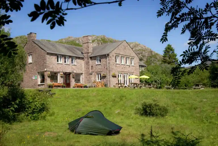
Hostel · Eskdale — Shared and private rooms, a self-catering kitchen and woodland grounds.
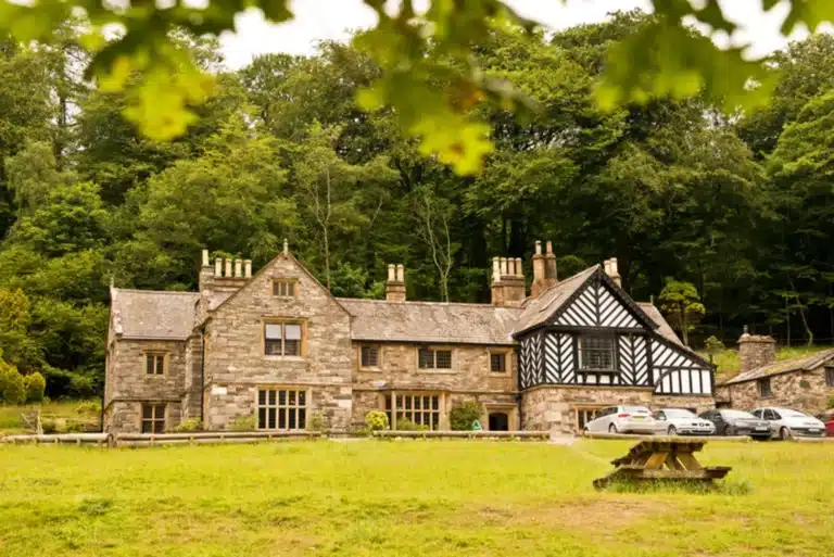
Hostel · Wasdale / Wastwater — Lakeside historic house, shared and private rooms, and a self-catering kitchen.
Some property pages contain affiliate booking links. We may earn a commission from qualifying bookings at no extra cost to you.